
Tacna topographic map
Interactive map
Click on the map to display elevation.
About this map
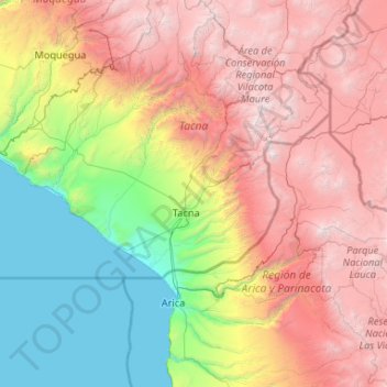
Name: Tacna topographic map, elevation, terrain.
Location: Tacna, Pérou (-18.91175 -71.20886 -16.91175 -69.20886)
Average elevation: 7,503 ft
Minimum elevation: 0 ft
Maximum elevation: 19,403 ft
Other topographic maps
Click on a map to view its topography, its elevation and its terrain.
Volcán Tutupaca
Volcán Tutupaca, Camilaca, Candarave, Tacna, Pérou
Average elevation: 17,441 ft