
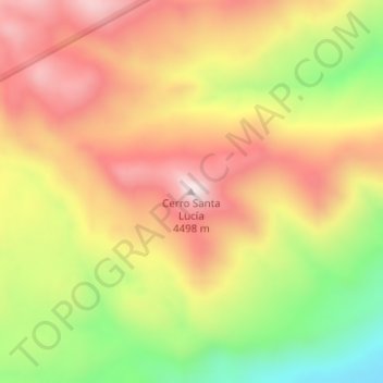
Cerro Santa Lucía topographic map
Interactive map
Click on the map to display elevation.
About this map
Name: Cerro Santa Lucía topographic map, elevation, terrain.
Location: Cerro Santa Lucía, Iglesia, San Juan, Argentina (-29.85719 -69.78028 -29.85709 -69.78018)
Average elevation: 13,835 ft
Minimum elevation: 12,762 ft
Maximum elevation: 14,692 ft
Other topographic maps
Click on a map to view its topography, its elevation and its terrain.
Punta Negra
Punta Negra, Valle Fértil, San Juan, Argentina
Average elevation: 6,237 ft
Las Lomitas
Argentina > San Juan > Las Lomitas
Las Lomitas, Albardón, San Juan, Argentina
Average elevation: 2,051 ft
Villa San Justo
Argentina > San Juan > Villa San Justo
Villa San Justo, Rivadavia, San Juan, 5407, Argentina
Average elevation: 2,293 ft