
Guellal topographic map
Interactive map
Click on the map to display elevation.
About this map
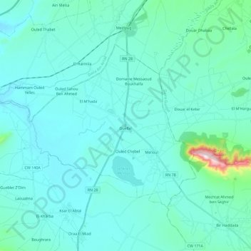
Name: Guellal topographic map, elevation, terrain.
Location: Guellal, Daïra Aïn Oulmane, Sétif, Algérie (35.97655 5.17595 36.09526 5.40263)
Average elevation: 3,061 ft
Minimum elevation: 2,877 ft
Maximum elevation: 4,734 ft
Other topographic maps
Click on a map to view its topography, its elevation and its terrain.
Draa El Miad
Algérie > Sétif > Daïra Aïn Oulmane > Aïn Oulmane
Draa El Miad, Aïn Oulmane, Daïra Aïn Oulmane, Sétif, 19042, Algérie
Average elevation: 2,979 ft
Ksar El Abtal
Algérie > Sétif > Daïra Aïn Oulmane
Ksar El Abtal, Daïra Aïn Oulmane, Sétif, Algérie
Average elevation: 3,114 ft
Aïn Oulmane
Algérie > Sétif > Daïra Aïn Oulmane
Aïn Oulmane, Daïra Aïn Oulmane, Sétif, Algérie
Average elevation: 3,278 ft