Geolocate

Payangan topographic map

Click on the map to display elevation.

About this map

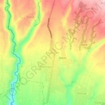
Name: Payangan topographic map, elevation, terrain.

Location: Payangan, Gianyar, Bali, 80561, Indonesia (-8.44527 115.22552 -8.40527 115.26552)

Average elevation: 1,391 ft

Minimum elevation: 935 ft

Maximum elevation: 1,759 ft

Other topographic maps

Click on a map to view its topography, its elevation and its terrain.

Ubud District

Indonesia > Bali > Gianyar

Average elevation: 650 ft

Pejeng

Indonesia > Bali > Gianyar

Average elevation: 659 ft

Gear up for your next adventure:

🛡️Insect Repellent - Protection against bugs during outdoor activities
Solar GPS Watches - Advanced multisport watches with built-in topographic maps
📌Outdoor GPS Map App - Apps and devices for digital topographic navigation
🔥Camping Stove - Portable stove for camping and backcountry cooking
🚑Emergency Bivvies - Heat-reflective sleeping bags for survival situations

As an Amazon Associate, this site earns from qualifying purchases at no extra cost to you.