
Make a donation
Gear up for your next adventure:
As an Amazon Associate, this site earns from qualifying purchases at no extra cost to you.
LaFollette topographic map
Click on the map to display elevation.
Make a donation
Gear up for your next adventure:
As an Amazon Associate, this site earns from qualifying purchases at no extra cost to you.
LaFollette
According to the United States Census Bureau, the city has a total area of 4.9 sq mi (12.7 km2), all land. The elevation varies around the city, around 1,050 ft (320 m) in the valley areas to 1,500 ft (460 m) on ridge tops. The average elevation is around 1,150 ft (350 m).
Make a donation
Gear up for your next adventure:
As an Amazon Associate, this site earns from qualifying purchases at no extra cost to you.
About this map
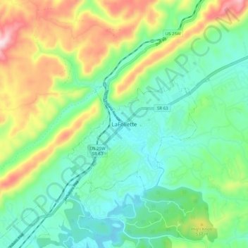
Name: LaFollette topographic map, elevation, terrain.
Average elevation: 1,427 ft
Minimum elevation: 988 ft
Maximum elevation: 2,382 ft
Campbell County trails, hiking, mountain biking, running and outdoor activities
Make a donation
Gear up for your next adventure:
As an Amazon Associate, this site earns from qualifying purchases at no extra cost to you.