
Thank you for supporting this site ❤️
Make a donation
Make a donation
Gear up for your next adventure:
As an Amazon Associate, this site earns from qualifying purchases at no extra cost to you.
Bayou topographic map
Click on the map to display elevation.
Thank you for supporting this site ❤️
Make a donation
Make a donation
Gear up for your next adventure:
As an Amazon Associate, this site earns from qualifying purchases at no extra cost to you.
About this map
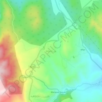
Name: Bayou topographic map, elevation, terrain.
Location: Bayou, Oued Taga, Teniet El Abed district, Batna, 12200, Algeria (35.40445 6.32447 35.44445 6.36447)
Average elevation: 4,764 ft
Minimum elevation: 4,304 ft
Maximum elevation: 5,614 ft
Thank you for supporting this site ❤️
Make a donation
Make a donation
Gear up for your next adventure:
As an Amazon Associate, this site earns from qualifying purchases at no extra cost to you.