
Rikers Island topographic map
Interactive map
Click on the map to display elevation.
About this map
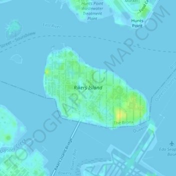
Name: Rikers Island topographic map, elevation, terrain.
Location: Rikers Island, Bronx County, New York City, New York, USA (40.78537 -73.89269 40.79838 -73.87089)
Average elevation: 7 ft
Minimum elevation: -39 ft
Maximum elevation: 59 ft
Other topographic maps
Click on a map to view its topography, its elevation and its terrain.
Harlem
USA > New York > New York City
Harlem, Manhattan, Manhattan Community Board 10, New York County, New York City, New York, USA
Average elevation: 52 ft
Chinatown
USA > New York > New York City
Chinatown, Manhattan, Manhattan Community Board 2, New York County, New York City, New York, USA
Average elevation: 39 ft
Governors Island
USA > New York > New York City
Governors Island, Manhattan Community Board 1, New York County, New York City, New York, USA
Average elevation: 3 ft