
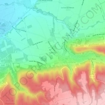
Le Vernay topographic map
Interactive map
Click on the map to display elevation.
About this map
Name: Le Vernay topographic map, elevation, terrain.
Average elevation: 1,050 ft
Minimum elevation: 758 ft
Maximum elevation: 1,473 ft
Other topographic maps
Click on a map to view its topography, its elevation and its terrain.
Saint-Didier
France > Auvergne-Rhône-Alpes > Drôme > Lens-Lestang
Saint-Didier, Lens-Lestang, Valence, Drôme, Auvergne-Rhône-Alpes, France métropolitaine, 26210, France
Average elevation: 1,165 ft
Pignerol
France > Auvergne-Rhône-Alpes > Drôme > Lens-Lestang
Pignerol, Le Bourgeat, Lens-Lestang, Valence, Drôme, Auvergne-Rhône-Alpes, France métropolitaine, 26210, France
Average elevation: 1,230 ft