
Bonacker topographic map
Interactive map
Click on the map to display elevation.
About this map
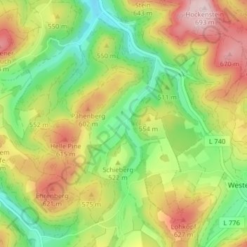
Name: Bonacker topographic map, elevation, terrain.
Average elevation: 1,709 ft
Minimum elevation: 1,280 ft
Maximum elevation: 2,251 ft
Other topographic maps
Click on a map to view its topography, its elevation and its terrain.
Hennesee
Duitsland > Noordrijn-Westfalen > Hochsauerlandkreis > Meschede > Berghausen
Hennesee, Berghausen, Meschede, Hochsauerlandkreis, Noordrijn-Westfalen, Duitsland
Average elevation: 1,250 ft
Grevenstein
Duitsland > Noordrijn-Westfalen > Hochsauerlandkreis > Meschede
Grevenstein, Meschede, Hochsauerlandkreis, Noordrijn-Westfalen, Duitsland
Average elevation: 1,368 ft
Löllinghausen
Duitsland > Noordrijn-Westfalen > Hochsauerlandkreis > Meschede
Löllinghausen, Meschede, Hochsauerlandkreis, Noordrijn-Westfalen, 59872, Duitsland
Average elevation: 1,345 ft