
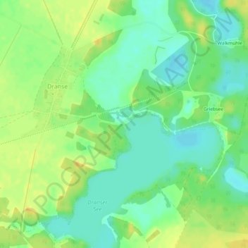
Badestelle Dranser See topographic map
Interactive map
Click on the map to display elevation.
About this map
Name: Badestelle Dranser See topographic map, elevation, terrain.
Average elevation: 256 ft
Minimum elevation: 217 ft
Maximum elevation: 295 ft
Other topographic maps
Click on a map to view its topography, its elevation and its terrain.
16909
Deutschland > Brandenburg > Ostprignitz-Ruppin > Wittstock/Dosse
16909, Wittstock/Dosse, Ostprignitz-Ruppin, Brandenburg, Deutschland
Average elevation: 256 ft
Dranser See
Deutschland > Brandenburg > Ostprignitz-Ruppin > Wittstock/Dosse
Dranser See, Schweinrich, Wittstock/Dosse, Ostprignitz-Ruppin, Brandenburg, Deutschland
Average elevation: 259 ft
Neu Cölln
Deutschland > Brandenburg > Ostprignitz-Ruppin > Wittstock/Dosse
Neu Cölln, Wittstock/Dosse, Ostprignitz-Ruppin, Brandenburg, Deutschland
Average elevation: 285 ft
Schweinrich
Deutschland > Brandenburg > Ostprignitz-Ruppin > Wittstock/Dosse
Schweinrich, Wittstock/Dosse, Ostprignitz-Ruppin, Brandenburg, Deutschland
Average elevation: 269 ft
Sewekow
Deutschland > Brandenburg > Ostprignitz-Ruppin > Wittstock/Dosse > Sewekow
Sewekow, Wittstock/Dosse, Ostprignitz-Ruppin, Brandenburg, Deutschland
Average elevation: 256 ft