
Machacamarca de Potosi topographic map
Interactive map
Click on the map to display elevation.
About this map
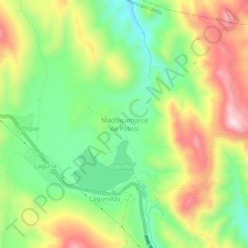
Name: Machacamarca de Potosi topographic map, elevation, terrain.
Average elevation: 13,133 ft
Minimum elevation: 12,595 ft
Maximum elevation: 13,839 ft
Other topographic maps
Click on a map to view its topography, its elevation and its terrain.
Belen
Bolivia > Potosí > Provincia Rafael Bustillo > Municipio Uncía
Belen, Municipio Uncía, Provincia Rafael Bustillo, Potosí, Bolivia
Average elevation: 12,195 ft