
Make a donation
Gear up for your next adventure:
As an Amazon Associate, this site earns from qualifying purchases at no extra cost to you.
Nyeri topographic map
Click on the map to display elevation.
Make a donation
Gear up for your next adventure:
As an Amazon Associate, this site earns from qualifying purchases at no extra cost to you.
Nyeri
Nyeri has tarmacked roads, and the county and national governments are upgrading many of them. Houses have drinking water on tap, but sewage provision is through soak pits, pit latrines and septic tanks are still widespread. The city's topography allows nature and gravity to take care of most of the city's storm water drainage.
Make a donation
Gear up for your next adventure:
As an Amazon Associate, this site earns from qualifying purchases at no extra cost to you.
About this map
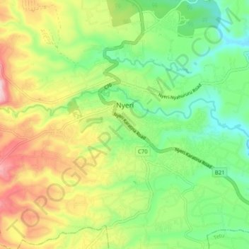
Name: Nyeri topographic map, elevation, terrain.
Location: Nyeri, Nyeri Central, Nyeri, Central Kenya, Kenya (-0.44526 36.90774 -0.40563 36.98616)
Average elevation: 5,892 ft
Minimum elevation: 5,427 ft
Maximum elevation: 6,604 ft
Make a donation
Gear up for your next adventure:
As an Amazon Associate, this site earns from qualifying purchases at no extra cost to you.