
Yatton Park topographic map
Interactive map
Click on the map to display elevation.
About this map
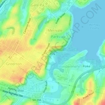
Name: Yatton Park topographic map, elevation, terrain.
Average elevation: 62 ft
Minimum elevation: -3 ft
Maximum elevation: 171 ft
Other topographic maps
Click on a map to view its topography, its elevation and its terrain.
Tauranga
New Zealand > Bay of Plenty > Tauranga
Tauranga, Tauranga City, Bay of Plenty, New Zealand
Average elevation: 33 ft
Moturiki Island (Leisure Island)
New Zealand > Bay of Plenty > Tauranga
Moturiki Island (Leisure Island), Tauranga, Bay of Plenty, New Zealand
Average elevation: 26 ft
Wairoa River
New Zealand > Bay of Plenty > Tauranga
Wairoa River, Tauranga, Tauranga City, Bay of Plenty, 3171, New Zealand
Average elevation: 213 ft
Motiti Island
New Zealand > Bay of Plenty > Tauranga
Motiti Island, Tauranga, Bay of Plenty, New Zealand
Average elevation: 33 ft
Lake Aroarotamahine
New Zealand > Bay of Plenty > Tauranga
Lake Aroarotamahine, Tauranga, Tauranga City, Bay of Plenty, New Zealand
Average elevation: 269 ft
Mayor Island
New Zealand > Bay of Plenty > Tauranga
Mayor Island, Tauranga, Bay of Plenty, New Zealand
Average elevation: 233 ft