
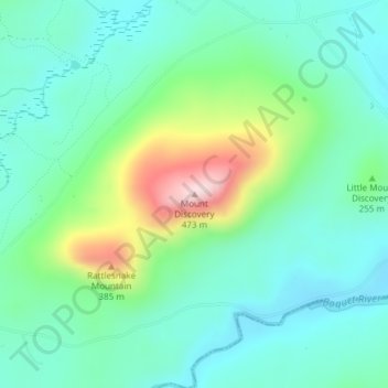
Mount Discovery topographic map
Interactive map
Click on the map to display elevation.
About this map
Name: Mount Discovery topographic map, elevation, terrain.
Location: Mount Discovery, Essex County, New York, 12950, VS (44.25556 -73.54546 44.25566 -73.54536)
Average elevation: 705 ft
Minimum elevation: 417 ft
Maximum elevation: 1,532 ft
Other topographic maps
Click on a map to view its topography, its elevation and its terrain.
Verdoy
VS > New York > Town of Colonie > Verdoy
Verdoy, Town of Colonie, Albany County, New York, 12110-1184, VS
Average elevation: 272 ft
Bramanville
VS > New York > Bramanville
Bramanville, Town of Cobleskill, Schoharie County, New York, 12092, VS
Average elevation: 1,050 ft
Ransomville
VS > New York > Ransomville
Ransomville, Porter Town, Niagara County, New York, 14131, VS
Average elevation: 318 ft