
Kreis 2 topographic map
Interactive map
Click on the map to display elevation.
About this map
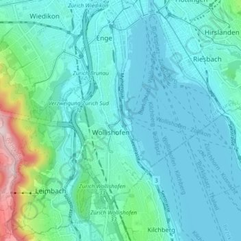
Name: Kreis 2 topographic map, elevation, terrain.
Location: Kreis 2, Zurich, District de Zurich, Zurich, Suisse (47.32022 8.50060 47.36952 8.55387)
Average elevation: 1,512 ft
Minimum elevation: 1,316 ft
Maximum elevation: 2,615 ft
Other topographic maps
Click on a map to view its topography, its elevation and its terrain.
Aussersihl
Aussersihl, Zurich, District de Zurich, Zurich, Suisse
Average elevation: 1,371 ft
Industriequartier
Industriequartier, Zurich, District de Zurich, Zurich, 8005, Suisse
Average elevation: 1,404 ft