
Valle de la Virgen topographic map
Interactive map
Click on the map to display elevation.
About this map
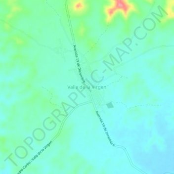
Name: Valle de la Virgen topographic map, elevation, terrain.
Average elevation: 200 ft
Minimum elevation: 135 ft
Maximum elevation: 463 ft
Other topographic maps
Click on a map to view its topography, its elevation and its terrain.
Río La Naranja
Ecuador > Guayas > Pedro Carbo > San Jerónimo
Río La Naranja, San Jerónimo, Parroquia Pedro Carbo, Pedro Carbo, Guayas, Ecuador
Average elevation: 837 ft
Pedro Carbo
Ecuador > Guayas > Pedro Carbo
Pedro Carbo, Parroquia Pedro Carbo, Pedro Carbo, Guayas, 091402, Ecuador
Average elevation: 167 ft