
Thank you for supporting this site ❤️
Make a donation
Make a donation
Gear up for your next adventure:
As an Amazon Associate, this site earns from qualifying purchases at no extra cost to you.
Briscol topographic map
Click on the map to display elevation.
Thank you for supporting this site ❤️
Make a donation
Make a donation
Gear up for your next adventure:
As an Amazon Associate, this site earns from qualifying purchases at no extra cost to you.
About this map
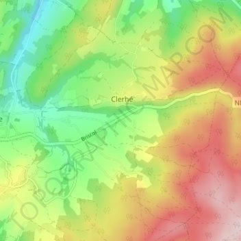
Name: Briscol topographic map, elevation, terrain.
Location: Briscol, Érezée, Marche-en-Famenne, Wallonia, 6997, Belgium (50.27260 5.57337 50.31260 5.61337)
Average elevation: 1,201 ft
Minimum elevation: 761 ft
Maximum elevation: 1,726 ft
Thank you for supporting this site ❤️
Make a donation
Make a donation
Gear up for your next adventure:
As an Amazon Associate, this site earns from qualifying purchases at no extra cost to you.