
Distriz topographic map
Interactive map
Click on the map to display elevation.
About this map
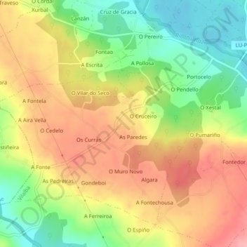
Name: Distriz topographic map, elevation, terrain.
Location: Distriz, Vilalba, Tierra Chá, Lugo, Galicia, España (43.28875 -7.76346 43.31228 -7.72409)
Average elevation: 1,552 ft
Minimum elevation: 1,352 ft
Maximum elevation: 1,732 ft
Other topographic maps
Click on a map to view its topography, its elevation and its terrain.
Vilalba
España > Galicia > Tierra Chá > Vilalba
Vilalba, Tierra Chá, Lugo, Galicia, España
Average elevation: 1,670 ft
Árbol
España > Galicia > Tierra Chá > Vilalba
Árbol, Vilalba, Tierra Chá, Lugo, Galicia, España
Average elevation: 1,368 ft