Geolocate

Edwardsville topographic map

Click on the map to display elevation.

About this map

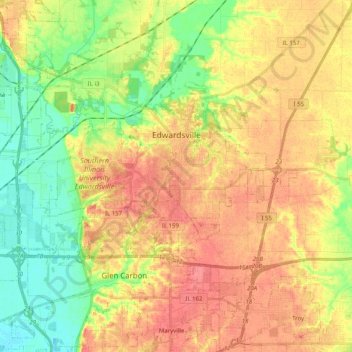
Name: Edwardsville topographic map, elevation, terrain.

Location: Edwardsville, Madison County, Illinois, United States (38.76021 -90.08611 38.82536 -89.88358)

Average elevation: 512 ft

Minimum elevation: 407 ft

Maximum elevation: 604 ft

Madison County trails, hiking, mountain biking, running and outdoor activities

Other topographic maps

Click on a map to view its topography, its elevation and its terrain.

North Venice

United States > Illinois > Madison County > Venice

Average elevation: 413 ft

North Alton

United States > Illinois > Madison County > Godfrey

Average elevation: 587 ft

Bethalto

United States > Illinois > Madison County > Bethalto > Bethalto

Average elevation: 512 ft

Alton

United States > Illinois > Madison County > Alton

Average elevation: 482 ft

Gear up for your next adventure:

🔥Fast-Boil Camping Stoves - Efficient cooking systems for quick trail meals
📌Outdoor GPS Map App - Apps and devices for digital topographic navigation
🪶Compact Camp Shovel - Folding shovel for campsite tasks
🧥Men's Rain Shells - Premium waterproof and breathable jackets for mountain weather
🥩Freeze-Dried Meals - Nutritious and lightweight food for remote expeditions

As an Amazon Associate, this site earns from qualifying purchases at no extra cost to you.