
Cumilla topographic map
Interactive map
Click on the map to display elevation.
About this map
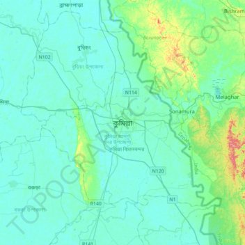
Name: Cumilla topographic map, elevation, terrain.
Average elevation: 52 ft
Minimum elevation: 13 ft
Maximum elevation: 289 ft
Other topographic maps
Click on a map to view its topography, its elevation and its terrain.
Rajeshpur Eco-Park
Bangladesh > Chattogram Division > Cumilla Adarsha Sadar Upazila
Rajeshpur Eco-Park, Cumilla Adarsha Sadar Upazila, Cumilla District, Chattogram Division, Bangladesh
Average elevation: 49 ft
Lalmai
Bangladesh > Chattogram Division > Cumilla Adarsha Sadar Upazila
Lalmai, Cumilla Adarsha Sadar Upazila, Cumilla District, Chattogram Division, Bangladesh
Average elevation: 46 ft