
Loh topographic map
Interactive map
Click on the map to display elevation.
About this map
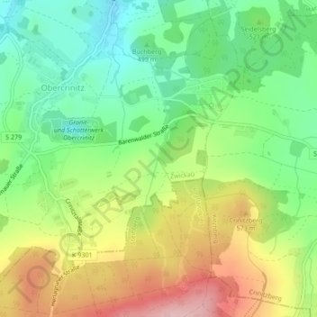
Name: Loh topographic map, elevation, terrain.
Location: Loh, Kirchberg, Zwickau, Saxony, 08147, Germany (50.55431 12.49233 50.57743 12.49970)
Average elevation: 1,696 ft
Minimum elevation: 1,430 ft
Maximum elevation: 2,070 ft
Other topographic maps
Click on a map to view its topography, its elevation and its terrain.
Löbau
Germany > Saxony > Görlitz - Zhorjelc
Löbau, Görlitz - Zhorjelc, Saxony, 02708, Germany
Average elevation: 896 ft
Marienberg
Germany > Saxony > Erzgebirgskreis
Marienberg, Erzgebirgskreis, Saxony, 09496, Germany
Average elevation: 2,156 ft
Bautzen - Budyšin
Bautzen - Budyšin, Bautzen, Saxony, 02625, Germany
Average elevation: 689 ft
Grimma
Germany > Saxony > Landkreis Leipzig > Grimma
Grimma, Landkreis Leipzig, Saxony, 04668, Germany
Average elevation: 531 ft
Schkeuditz
Germany > Saxony > Schkeuditz
Schkeuditz, Nordsachsen, Saxony, 04435, Germany
Average elevation: 381 ft
Northern Eagle Owl
Northern Eagle Owl, Zittau, Görlitz, Saxony, 02797, Germany
Average elevation: 1,444 ft
Centre North West
Centre North West, Mitte, Leipzig, Saxony, 04105, Germany
Average elevation: 364 ft
Fichtelberg
Germany > Saxony > Oberwiesenthal
Fichtelberg, Oberwiesenthal, Erzgebirgskreis, Saxony, 09484, Germany
Average elevation: 3,406 ft