
Scherpenheuvel topographic map
Interactive map
Click on the map to display elevation.
About this map
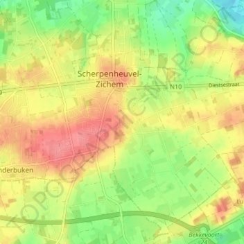
Name: Scherpenheuvel topographic map, elevation, terrain.
Average elevation: 151 ft
Minimum elevation: 33 ft
Maximum elevation: 253 ft
Other topographic maps
Click on a map to view its topography, its elevation and its terrain.
Averbode
België > Vlaams-Brabant > Leuven > Scherpenheuvel-Zichem
Averbode, Scherpenheuvel-Zichem, Leuven, Vlaams-Brabant, Vlaanderen, 3271, België
Average elevation: 69 ft
Zichem
België > Vlaams-Brabant > Leuven > Scherpenheuvel-Zichem
Zichem, Scherpenheuvel-Zichem, Leuven, Vlaams-Brabant, Vlaanderen, België
Average elevation: 89 ft