
Katakolo topographic map
Interactive map
Click on the map to display elevation.
About this map
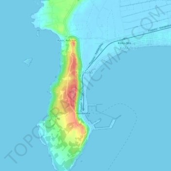
Name: Katakolo topographic map, elevation, terrain.
Average elevation: 23 ft
Minimum elevation: -16 ft
Maximum elevation: 262 ft
Other topographic maps
Click on a map to view its topography, its elevation and its terrain.
Kavouri
Greece > Peloponnese, Western Greece and the Ionian > Elis Regional Unit > Municipality of Pyrgos
Kavouri, Municipality of Pyrgos, Elis Regional Unit, Western Greece, Peloponnese, Western Greece and the Ionian, 270 67, Greece
Average elevation: 3 ft