
Mattersburg topographic map
Interactive map
Click on the map to display elevation.
About this map
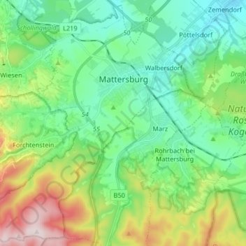
Name: Mattersburg topographic map, elevation, terrain.
Location: Mattersburg, Bezirk Mattersburg, Burgenland, 7210, Österreich (47.67852 16.30904 47.76329 16.44012)
Average elevation: 1,089 ft
Minimum elevation: 640 ft
Maximum elevation: 2,211 ft
Vor Christi Geburt war das Gebiet Teil des keltischen Königreiches Noricum und gehörte zur Umgebung der keltischen Höhensiedlung Burg auf dem Schwarzenbacher Burgberg.