
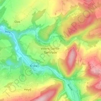
Villers-Sainte-Gertrude topographic map
Interactive map
Click on the map to display elevation.
About this map
Name: Villers-Sainte-Gertrude topographic map, elevation, terrain.
Average elevation: 837 ft
Minimum elevation: 495 ft
Maximum elevation: 1,230 ft
Other topographic maps
Click on a map to view its topography, its elevation and its terrain.
Aisne
Belgique > Luxembourg > Marche-en-Famenne > Durbuy
Aisne, Durbuy, Marche-en-Famenne, Luxembourg, Wallonie, Belgique
Average elevation: 814 ft
Bomal
Belgique > Luxembourg > Marche-en-Famenne > Durbuy
Bomal, Durbuy, Marche-en-Famenne, Luxembourg, Wallonie, Belgique
Average elevation: 663 ft
Tohogne
Belgique > Luxembourg > Marche-en-Famenne > Durbuy
Tohogne, Durbuy, Marche-en-Famenne, Luxembourg, Wallonie, 6941, Belgique
Average elevation: 738 ft
Barvaux
Belgique > Luxembourg > Marche-en-Famenne > Durbuy
Barvaux, Durbuy, Marche-en-Famenne, Luxembourg, Wallonie, 6940, Belgique
Average elevation: 673 ft
Bende
Belgique > Luxembourg > Marche-en-Famenne > Durbuy
Bende, Durbuy, Marche-en-Famenne, Luxembourg, Wallonie, Belgique
Average elevation: 853 ft
Heyd
Belgique > Luxembourg > Marche-en-Famenne > Durbuy
Heyd, Durbuy, Marche-en-Famenne, Luxembourg, Wallonie, Belgique
Average elevation: 853 ft
Izier
Belgique > Luxembourg > Marche-en-Famenne > Durbuy
Izier, Durbuy, Marche-en-Famenne, Luxembourg, Wallonie, Belgique
Average elevation: 820 ft
Borlon
Belgique > Luxembourg > Marche-en-Famenne > Durbuy
Borlon, Durbuy, Marche-en-Famenne, Luxembourg, Wallonie, Belgique
Average elevation: 899 ft
Septon
Belgique > Luxembourg > Marche-en-Famenne > Durbuy
Septon, Durbuy, Marche-en-Famenne, Luxembourg, Wallonie, 6941, Belgique
Average elevation: 774 ft
Wéris
Belgique > Luxembourg > Marche-en-Famenne > Durbuy
Wéris, Durbuy, Marche-en-Famenne, Luxembourg, Wallonie, Belgique
Average elevation: 935 ft
Oppagne
Belgique > Luxembourg > Marche-en-Famenne > Durbuy > Wéris
Oppagne, Wéris, Durbuy, Marche-en-Famenne, Luxembourg, Wallonie, 6997, Belgique
Average elevation: 922 ft
Herbet
Belgique > Luxembourg > Marche-en-Famenne > Durbuy > Bomal
Herbet, Bomal, Durbuy, Marche-en-Famenne, Luxembourg, Wallonie, Belgique
Average elevation: 663 ft
Jenneret
Belgique > Luxembourg > Marche-en-Famenne > Durbuy
Jenneret, Durbuy, Marche-en-Famenne, Luxembourg, Wallonie, 4590, Belgique
Average elevation: 814 ft