
Charleston topographic map
Click on the map to display elevation.
Charleston
Charleston is characterized by its relatively flat topography, with an average elevation of about 10 feet above sea level, making it prone to flooding during heavy rains and storms. The city is situated on a peninsula bordered by the Ashley River to the west and the Cooper River to the east, creating a natural harbor that has historically contributed to its significance as a port city. The terrain includes a mix of marshlands, low-lying coastal areas, and sandy beaches, particularly along the nearby islands of Folly Beach and Sullivan's Island. This coastal environment is complemented by an intricate system of waterways, creeks, and tidal estuaries, which support diverse ecosystems and provide recreational opportunities for residents and visitors alike. The area's rich soil and mild climate further enhance its lush vegetation, contributing to the charm of Charleston's historic gardens and parks.
About this map
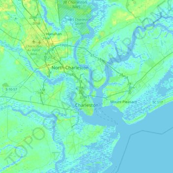
Name: Charleston topographic map, elevation, terrain.
Location: Charleston, Charleston County, South Carolina, United States (32.66851 -80.14385 32.97352 -79.79706)
Average elevation: 13 ft
Minimum elevation: -16 ft
Maximum elevation: 75 ft
Charleston County trails, hiking, mountain biking, running and outdoor activities
Other topographic maps
Click on a map to view its topography, its elevation and its terrain.
Hobcaw Point
United States > South Carolina > Charleston County > Mount Pleasant
Average elevation: 13 ft
Saint Andrews Heights
United States > South Carolina > Charleston County > Charleston
Average elevation: 16 ft
Pinewood Vista
United States > South Carolina > Charleston County > North Charleston
Average elevation: 30 ft
Palmetto Fort
United States > South Carolina > Charleston County > Mount Pleasant
Average elevation: 13 ft
Fenwick Crossroads
United States > South Carolina > Charleston County > Charleston
Average elevation: 16 ft
Jamestown Estates
United States > South Carolina > Charleston County > James Island
Average elevation: 13 ft
Brook Green Meadow
United States > South Carolina > Charleston County > Mount Pleasant
Average elevation: 13 ft
Remleys Point
United States > South Carolina > Charleston County > Mount Pleasant
Average elevation: 13 ft
Camp Saint Christopher
United States > South Carolina > Charleston County > Seabrook Island
Average elevation: 7 ft
North Charleston Wannamaker County Park
United States > South Carolina > Charleston County > North Charleston
Average elevation: 26 ft
Forest Park
United States > South Carolina > Charleston County > Charleston > Maryville
Average elevation: 16 ft
Liberty Hill
United States > South Carolina > Charleston County > North Charleston
Average elevation: 23 ft
Wando Estates
United States > South Carolina > Charleston County > Mount Pleasant
Average elevation: 16 ft
Moss Park
United States > South Carolina > Charleston County > Mount Pleasant
Average elevation: 13 ft
Forest Trail
United States > South Carolina > Charleston County > Isle of Palms
Average elevation: 3 ft
Saint Andrews Heights
United States > South Carolina > Charleston County > Charleston
Average elevation: 16 ft
Ashley Junction
United States > South Carolina > Charleston County > North Charleston
Average elevation: 23 ft
Camp Saint Christopher
United States > South Carolina > Charleston County > Seabrook Island
Average elevation: 7 ft
North Charleston
United States > South Carolina > Charleston County > North Charleston
Average elevation: 16 ft
Northwood Estates
United States > South Carolina > Charleston County > North Charleston > Northwood Estates
Average elevation: 26 ft
Country Club Estates
United States > South Carolina > Charleston County > Charleston
Average elevation: 10 ft