
Bahour Taluk topographic map
Interactive map
Click on the map to display elevation.
About this map
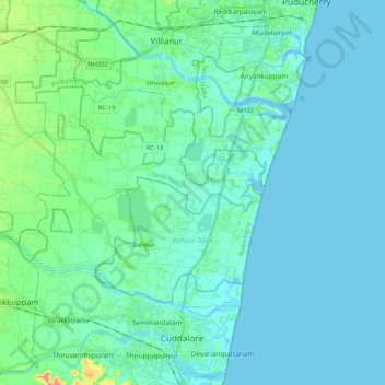
Name: Bahour Taluk topographic map, elevation, terrain.
Location: Bahour Taluk, Puducherry District, Puducherry, India (11.77523 79.59942 11.89131 79.80680)
Average elevation: 23 ft
Minimum elevation: -16 ft
Maximum elevation: 144 ft
Other topographic maps
Click on a map to view its topography, its elevation and its terrain.
Puducherry
India > Puducherry > Puducherry Taluk
Puducherry, Puducherry Taluk, Puducherry District, Puducherry, 605001, India
Average elevation: 33 ft
Bahour
India > Puducherry > Bahour Taluk
Bahour, Bahour Taluk, Puducherry District, Puducherry, 607402, India
Average elevation: 30 ft
Kalapet
India > Puducherry > Ozhukarai Taluk
Kalapet, Ozhukarai Taluk, Puducherry District, Puducherry, 605014, India
Average elevation: 46 ft
Oulgaret
India > Puducherry > Ozhukarai Taluk > Oulgaret
Oulgaret, Ozhukarai Taluk, Puducherry district, Puducherry, 605005, India
Average elevation: 59 ft
Puducherry Taluk
Puducherry Taluk, Puducherry district, Puducherry, India
Average elevation: 20 ft
Yanam
India > Puducherry > Yanam Taluk
Yanam, Yanam Taluk, Yanam District, Puducherry, 533464, India
Average elevation: 16 ft