
Thank you for supporting this site ❤️
Make a donation
Make a donation
Gear up for your next adventure:
As an Amazon Associate, this site earns from qualifying purchases at no extra cost to you.
Loja topographic map
Click on the map to display elevation.
Thank you for supporting this site ❤️
Make a donation
Make a donation
Gear up for your next adventure:
As an Amazon Associate, this site earns from qualifying purchases at no extra cost to you.
About this map
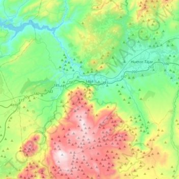
Name: Loja topographic map, elevation, terrain.
Location: Loja, Comarca de Loja, Granada, Andalusia, Spain (37.01234 -4.32762 37.29261 -4.02530)
Average elevation: 2,657 ft
Minimum elevation: 1,273 ft
Maximum elevation: 5,446 ft
Thank you for supporting this site ❤️
Make a donation
Make a donation
Gear up for your next adventure:
As an Amazon Associate, this site earns from qualifying purchases at no extra cost to you.
Other topographic maps
Click on a map to view its topography, its elevation and its terrain.
Fuente Camacho
Spain > Andalusia > Comarca de Loja > Loja > Fuente Camacho
Average elevation: 2,654 ft