
Muri topographic map
Interactive map
Click on the map to display elevation.
About this map
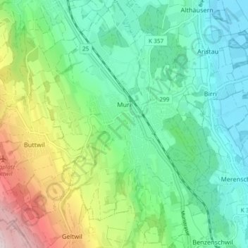
Name: Muri topographic map, elevation, terrain.
Location: Muri, Bezirk Muri, Aargau, 5630, Schweiz (47.24689 8.31388 47.29664 8.36318)
Average elevation: 1,696 ft
Minimum elevation: 1,243 ft
Maximum elevation: 2,799 ft
Other topographic maps
Click on a map to view its topography, its elevation and its terrain.
Oberrüti
Schweiz > Aargau > Bezirk Muri
Oberrüti, Bezirk Muri, Aargau, 5647, Schweiz
Average elevation: 1,427 ft
Merenschwand
Schweiz > Aargau > Bezirk Muri
Merenschwand, Bezirk Muri, Aargau, 5634, Schweiz
Average elevation: 1,417 ft