
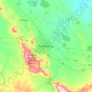
Rustenburg topographic map
Interactive map
Click on the map to display elevation.
About this map
Name: Rustenburg topographic map, elevation, terrain.
Average elevation: 3,993 ft
Minimum elevation: 3,373 ft
Maximum elevation: 5,761 ft
Rustenburg has a humid subtropical climate (Köppen Cwa), with a relatively high degree of diurnal temperature variation due to the high elevation. It has very warm summers (from December to February) and mild winters (from June to August). Due to the altitude, summers are not quite as hot as one might expect. Precipitation occurs mainly in summer. There is occasional frost at night in winter.
Other topographic maps
Click on a map to view its topography, its elevation and its terrain.
Kagiso
South Africa > North West > Bojanala Platinum District Municipality > Moses Kotane Local Municipality
Kagiso, Moses Kotane Local Municipality, Bojanala Platinum District Municipality, North West, South Africa
Average elevation: 3,727 ft
Valley of Waves
South Africa > North West > Bojanala Platinum District Municipality > Moses Kotane Local Municipality > Sun City
Valley of Waves, Weaver Street, Sun Village, Moses Kotane Ward 14, Sun City, Moses Kotane Local Municipality, Bojanala Platinum District Municipality, North West, South Africa
Average elevation: 3,855 ft
Bapong
South Africa > North West > Bojanala Platinum District Municipality > Madibeng Local Municipality
Bapong, Madibeng Local Municipality, Bojanala Platinum District Municipality, North West, South Africa
Average elevation: 3,924 ft
Moses Kotane Local Municipality
South Africa > North West > Bojanala Platinum District Municipality
Moses Kotane Local Municipality, Bojanala Platinum District Municipality, North West, South Africa
Average elevation: 3,556 ft
Moretele Local Municipality
South Africa > North West > Bojanala Platinum District Municipality
Moretele Local Municipality, Bojanala Platinum District Municipality, North West, South Africa
Average elevation: 3,468 ft