
Ghassira topographic map
Interactive map
Click on the map to display elevation.
About this map
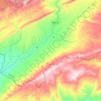
Name: Ghassira topographic map, elevation, terrain.
Location: Ghassira, Daïra de T'Kout, Batna, Algérie (34.97884 6.08830 35.14457 6.36028)
Average elevation: 3,812 ft
Minimum elevation: 1,785 ft
Maximum elevation: 6,339 ft
Other topographic maps
Click on a map to view its topography, its elevation and its terrain.
T'Kout
Algérie > Batna > Daïra de T'Kout
T'Kout, Daïra de T'Kout, Batna, Algérie
Average elevation: 4,321 ft
Ighzer Amellal
Algérie > Batna > Daïra de T'Kout
Ighzer Amellal, Daïra de T'Kout, Batna, Algérie
Average elevation: 3,182 ft