
Roermond topographic map
Interactive map
Click on the map to display elevation.
About this map
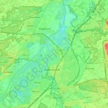
Name: Roermond topographic map, elevation, terrain.
Location: Roermond, Limburg, Niederlande (51.15875 5.91665 51.25868 6.08602)
Average elevation: 82 ft
Minimum elevation: 30 ft
Maximum elevation: 200 ft
Other topographic maps
Click on a map to view its topography, its elevation and its terrain.
Roermond
Niederlande > Limburg > Roermond
Roermond, Limburg, Niederlande, 6041HT, Niederlande
Average elevation: 128 ft