
Pontprennau topographic map
Interactive map
Click on the map to display elevation.
About this map
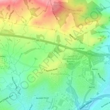
Name: Pontprennau topographic map, elevation, terrain.
Location: Pontprennau, Cardiff, Pays de Galles, CF, Royaume-Uni (51.52727 -3.15944 51.55535 -3.11885)
Average elevation: 203 ft
Minimum elevation: 39 ft
Maximum elevation: 446 ft
Other topographic maps
Click on a map to view its topography, its elevation and its terrain.
Llandaff
Royaume-Uni > Pays de Galles > Cardiff
Llandaff, Cardiff, Pays de Galles, CF, Royaume-Uni
Average elevation: 69 ft
Castle
Royaume-Uni > Pays de Galles > Cardiff
Castle, Cardiff, Pays de Galles, CF, Royaume-Uni
Average elevation: 46 ft