
Whirinaki Stream topographic map
Interactive map
Click on the map to display elevation.
About this map
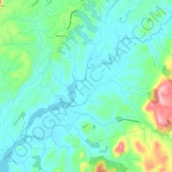
Name: Whirinaki Stream topographic map, elevation, terrain.
Average elevation: 1,083 ft
Minimum elevation: 935 ft
Maximum elevation: 1,545 ft
Other topographic maps
Click on a map to view its topography, its elevation and its terrain.
Ngakuru
New Zealand > Waikato > Rotorua > Ngakuru
Ngakuru, Rotorua, Waikato, 3077, New Zealand
Average elevation: 1,093 ft
Lake Ohakuri
New Zealand > Waikato > Rotorua
Lake Ohakuri, Dods Road, Rotorua, Rotorua District, Waikato, 3077, New Zealand
Average elevation: 1,368 ft