
Warwick topographic map
Interactive map
Click on the map to display elevation.
About this map
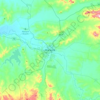
Name: Warwick topographic map, elevation, terrain.
Location: Warwick, Queensland, 4370, Australia (-28.37653 151.87118 -28.05653 152.19118)
Average elevation: 1,696 ft
Minimum elevation: 1,411 ft
Maximum elevation: 2,953 ft
Other topographic maps
Click on a map to view its topography, its elevation and its terrain.
Mount Greville
Australia > Queensland > Warwick
Mount Greville, Warwick, Queensland, 4370, Australia
Average elevation: 994 ft