
Mount Greville topographic map
Interactive map
Click on the map to display elevation.
About this map
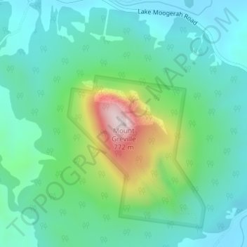
Name: Mount Greville topographic map, elevation, terrain.
Location: Mount Greville, Warwick, Queensland, 4370, Australia (-28.07456 152.50262 -28.07446 152.50272)
Average elevation: 994 ft
Minimum elevation: 528 ft
Maximum elevation: 2,411 ft
Other topographic maps
Click on a map to view its topography, its elevation and its terrain.
Warwick
Australia > Queensland > Warwick
Warwick, Queensland, 4370, Australia
Average elevation: 1,696 ft
Main Range National Park
Australia > Queensland > Warwick
Main Range National Park, Winder Trail, Warwick, Queensland, 4370, Australia
Average elevation: 1,673 ft