

Damascus topographic map
Click on the map to display elevation.
About this map
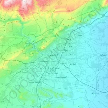
Name: Damascus topographic map, elevation, terrain.
Average elevation: 2,717 ft
Minimum elevation: 1,991 ft
Maximum elevation: 6,417 ft
Other topographic maps
Click on a map to view its topography, its elevation and its terrain.

Barada River
Syria > Damascus Governorate > Damascus Subdistrict > Sarouja Municipality
Average elevation: 2,474 ft

New Cham Suburb
Syria > Damascus Governorate > Damascus Subdistrict > Dummar Municipality
Average elevation: 2,854 ft

حديقة 17 نيسان
Syria > Damascus Governorate > Damascus Subdistrict > Kafr Sousa Municipality
Average elevation: 2,297 ft

Al Qabun Neighborhood
Syria > Damascus Governorate > Damascus Subdistrict > Al-Qaboun Municipality
Average elevation: 2,408 ft
Rukn ad-Din Municipality
Syria > Damascus Governorate > Damascus Subdistrict
Average elevation: 2,677 ft

Kafr Sousa Municipality
Syria > Damascus Governorate > Damascus Subdistrict
Average elevation: 2,300 ft


Mazzeh Basatin Neighbourhood
Syria > Damascus Governorate > Damascus Subdistrict > Kafr Sousa Municipality
Average elevation: 2,395 ft

Kafr Sousa Municipality
Syria > Damascus Governorate > Damascus Subdistrict
Average elevation: 2,300 ft


Al-Muhajerin Municipality
Syria > Damascus Governorate > Damascus Subdistrict
Average elevation: 2,615 ft
Barada River
Syria > Damascus Governorate > Damascus Subdistrict > Al-Qanawat Municipality
Average elevation: 2,306 ft

As-Salihiya Municipality
Syria > Damascus Governorate > Damascus Subdistrict
Average elevation: 2,746 ft

Al-Muhajerin Municipality
Syria > Damascus Governorate > Damascus Subdistrict
Average elevation: 2,615 ft
Al-Muhajerin Municipality
Syria > Damascus Governorate > Damascus Subdistrict
Average elevation: 2,615 ft

Al-Qaboun Municipality
Syria > Damascus Governorate > Damascus Subdistrict
Average elevation: 2,392 ft


Masakin Barza Neighborhood
Syria > Damascus Governorate > Damascus Subdistrict > Barza Municipality > Barzeh
Average elevation: 2,451 ft

Al-Qanawat Municipality
Syria > Damascus Governorate > Damascus Subdistrict
Average elevation: 2,290 ft
Rukn ad-Din Municipality
Syria > Damascus Governorate > Damascus Subdistrict
Average elevation: 2,713 ft
As-Salihiya Municipality
Syria > Damascus Governorate > Damascus Subdistrict
Average elevation: 2,746 ft
Al-Qanawat Municipality
Syria > Damascus Governorate > Damascus Subdistrict
Average elevation: 2,290 ft
Mazzeh 86 Neighborhood
Syria > Damascus Governorate > Damascus Subdistrict > Al-Mazza Municipality > Al Mazzeh
Average elevation: 2,661 ft
Al Mazra'a Neighborhood
Syria > Damascus Governorate > Damascus Subdistrict > As-Salihiya Municipality
Average elevation: 2,362 ft

Tishreen Park
Syria > Damascus Governorate > Damascus Subdistrict > Al-Muhajerin Municipality
Average elevation: 2,530 ft
Al-Muhajerin Municipality
Syria > Damascus Governorate > Damascus Subdistrict
Average elevation: 2,615 ft

Al-Muhajerin Municipality
Syria > Damascus Governorate > Damascus Subdistrict
Average elevation: 2,615 ft
Ash-Shaghour Municipality
Syria > Damascus Governorate > Damascus Subdistrict
Average elevation: 2,231 ft