
Navarra topographic map
Interactive map
Click on the map to display elevation.
About this map
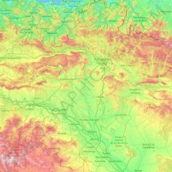
Name: Navarra topographic map, elevation, terrain.
Location: Navarra, Spanien (41.90989 -2.49994 43.31495 -0.72334)
Average elevation: 2,064 ft
Minimum elevation: -3 ft
Maximum elevation: 7,034 ft
Other topographic maps
Click on a map to view its topography, its elevation and its terrain.
Santiago
Spanien > Navarra > Mendigorría
Santiago, Mendigorría, Navarra, 31140, Spanien
Average elevation: 1,355 ft
Santa Cruz
Spanien > Navarra > Arce/Artzi
Santa Cruz, Arce/Artzi, Navarra, Spanien
Average elevation: 3,038 ft
Linares
Spanien > Navarra > Urraul Alto
Linares, Urraul Alto, Navarra, 31448, Spanien
Average elevation: 2,178 ft