
Beijós topographic map
Interactive map
Click on the map to display elevation.
About this map
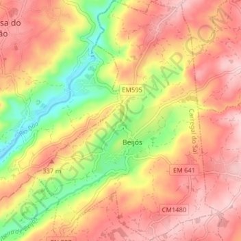
Name: Beijós topographic map, elevation, terrain.
Location: Beijós, Carregal do Sal, Viseu, Portugal (40.48901 -7.98346 40.53807 -7.93291)
Average elevation: 951 ft
Minimum elevation: 525 ft
Maximum elevation: 1,257 ft
Other topographic maps
Click on a map to view its topography, its elevation and its terrain.
Póvoa de Santo Amaro
Portugal > Viseu > Carregal do Sal > Parada
Póvoa de Santo Amaro, Parada, Carregal do Sal, Viseu, 3430-730, Portugal
Average elevation: 837 ft