
Madinat al Ilam topographic map
Interactive map
Click on the map to display elevation.
About this map
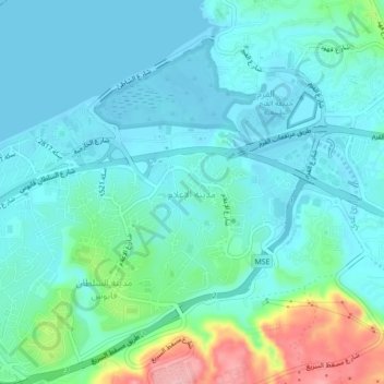
Name: Madinat al Ilam topographic map, elevation, terrain.
Location: Madinat al Ilam, Muscat, Muscat Governorate, 282, Oman (23.59000 58.46000 23.63000 58.50000)
Average elevation: 105 ft
Minimum elevation: -3 ft
Maximum elevation: 528 ft
Other topographic maps
Click on a map to view its topography, its elevation and its terrain.
Sedab
Oman > Muscat Governorate > Muscat
Sedab, Muscat, Muscat Governorate, 940, Oman
Average elevation: 144 ft
Al Azaiba North
Oman > Muscat Governorate > Muscat
Al Azaiba North, Muscat, Muscat Governorate, 600, Oman
Average elevation: 39 ft
Airport Heights
Oman > Muscat Governorate > Muscat
Airport Heights, Muscat, Muscat Governorate, Oman
Average elevation: 95 ft
Bawshar
Oman > Muscat Governorate > Muscat
Bawshar, Muscat, Muscat Governorate, 133, Oman
Average elevation: 440 ft