
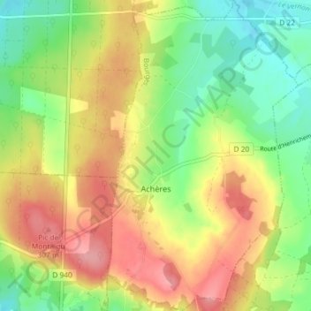
Achères topographic map
Interactive map
Click on the map to display elevation.
About this map
Name: Achères topographic map, elevation, terrain.
Average elevation: 860 ft
Minimum elevation: 689 ft
Maximum elevation: 1,050 ft
Other topographic maps
Click on a map to view its topography, its elevation and its terrain.
Lunery
France > Centre-Val de Loire > Cher
Lunery, Bourges, Cher, Centre-Val de Loire, France métropolitaine, 18400, France
Average elevation: 499 ft
Avord
France > Centre-Val de Loire > Cher
Avord, Bourges, Cher, Centre-Val de Loire, France métropolitaine, 18520, France
Average elevation: 571 ft
Ivry
France > Centre-Val de Loire > Cher > Vasselay
Ivry, Vasselay, Bourges, Cher, Centre-Val de Loire, France métropolitaine, 18110, France
Average elevation: 522 ft
Cornusse
France > Centre-Val de Loire > Cher > Cornusse
Cornusse, Saint-Amand-Montrond, Cher, Centre-Val de Loire, France métropolitaine, 18350, France
Average elevation: 636 ft
Rians
France > Centre-Val de Loire > Cher > Rians
Rians, Bourges, Cher, Centre-Val de Loire, France métropolitaine, 18220, France
Average elevation: 610 ft