
Town of Danby topographic map
Interactive map
Click on the map to display elevation.
About this map
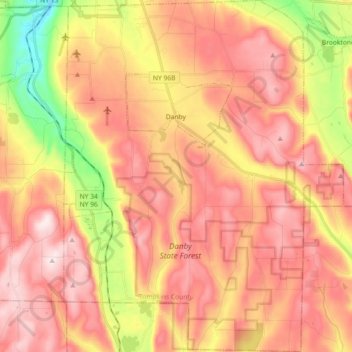
Name: Town of Danby topographic map, elevation, terrain.
Location: Town of Danby, Tompkins County, New York, United States (42.26275 -76.53851 42.39654 -76.39437)
Average elevation: 1,325 ft
Minimum elevation: 440 ft
Maximum elevation: 1,923 ft
Elevations range from approximately 450 feet above sea level where Cayuga Inlet crosses the northern town line, to about 1230 feet at Town Hall in Danby Hamlet, to just over 1800 feet at Dawes Hill in the southwestern part of the town and Roundtop in the southeastern part of the town. The dramatic hill and valley lands of Danby have sometimes been referred to as the 'Danby Highlands'.
Other topographic maps
Click on a map to view its topography, its elevation and its terrain.
City of Ithaca
United States > New York > Tompkins County
City of Ithaca, Tompkins County, New York, United States
Average elevation: 640 ft
Town of Newfield
United States > New York > Tompkins County
Town of Newfield, Tompkins County, New York, 14867, United States
Average elevation: 1,398 ft
Buttermilk Falls State Park
United States > New York > Tompkins County > Ithaca > Town of Danby
Buttermilk Falls State Park, Ithaca, Town of Danby, Tompkins County, New York, United States
Average elevation: 883 ft
East Ithaca
United States > New York > Tompkins County > Ithaca > East Ithaca
East Ithaca, Ithaca, Tompkins County, New York, United States
Average elevation: 922 ft
Town of Ithaca
United States > New York > Tompkins County
Town of Ithaca, Tompkins County, New York, United States
Average elevation: 945 ft
Town of Dryden
United States > New York > Tompkins County
Town of Dryden, Tompkins County, New York, United States
Average elevation: 1,411 ft
Waterburg
United States > New York > Tompkins County > Waterburg
Waterburg, Ulysses Town, Tompkins County, New York, 14886, United States
Average elevation: 1,043 ft