
Sandoy topographic map
Interactive map
Click on the map to display elevation.
About this map
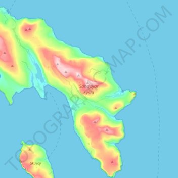
Name: Sandoy topographic map, elevation, terrain.
Location: Sandoy, Sandoy region, Faroe Islands (61.75291 -6.95291 61.91419 -6.63347)
Average elevation: 200 ft
Minimum elevation: -7 ft
Maximum elevation: 1,526 ft
Other topographic maps
Click on a map to view its topography, its elevation and its terrain.