
Shasta topographic map
Click on the map to display elevation.
Shasta
Shasta is a census-designated place (CDP) in Shasta County, California, United States. Shasta sits at an elevation of 843 feet (257 m). Its population is 1,043 as of the 2020 census, down from 1,771 from the 2010 census.
About this map
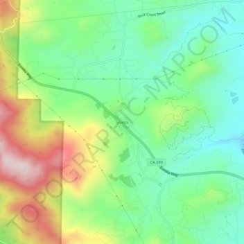
Name: Shasta topographic map, elevation, terrain.
Location: Shasta, Shasta County, California, 96087, United States (40.57932 -122.51196 40.61932 -122.47196)
Average elevation: 1,152 ft
Minimum elevation: 646 ft
Maximum elevation: 2,060 ft
Shasta County trails, hiking, mountain biking, running and outdoor activities
Other topographic maps
Click on a map to view its topography, its elevation and its terrain.
Palo Cedro
United States > California > Shasta County > Palo Cedro
Palo Cedro is located at 40°33′4″N 122°14′3″W / 40.55111°N 122.23417°W / 40.55111; -122.23417 (40.551091, −122.234255) at an elevation of 465 ft (143 m) above sea level.
Average elevation: 515 ft