Geolocate

Vernon topographic map

Click on the map to display elevation.

About this map

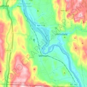
Name: Vernon topographic map, elevation, terrain.

Location: Vernon, Windham County, Vermont, 05354, United States (42.72696 -72.56535 42.82418 -72.45845)

Average elevation: 538 ft

Minimum elevation: 177 ft

Maximum elevation: 1,178 ft

Windham County trails, hiking, mountain biking, running and outdoor activities

Other topographic maps

Click on a map to view its topography, its elevation and its terrain.

South Wardsboro

United States > Vermont > Windham County > Wardsboro

Average elevation: 1,768 ft

Ames Hill

United States > Vermont > Windham County > Marlboro

Average elevation: 1,572 ft

West Wardsboro

United States > Vermont > Windham County > Wardsboro

Average elevation: 1,696 ft

Hogback Mountain

United States > Vermont > Windham County > Marlboro

Average elevation: 2,014 ft

Guilford

United States > Vermont > Windham County > Guilford

Average elevation: 607 ft

College Hill

United States > Vermont > Windham County > Jamaica

Average elevation: 1,578 ft

West Halifax

United States > Vermont > Windham County > Halifax

Average elevation: 1,460 ft

Stowe Mountain

United States > Vermont > Windham County > Halifax

Average elevation: 1,302 ft

Gear up for your next adventure:

🕶️GPS Smartphone Mount - Secure mount for phone navigation
🧤Tactile Hiking Gloves - Keep hands warm while operating GPS and smartphone screens
🎒Day Hiking Backpack - Lightweight backpack perfect for day trips and outdoor adventures
📚Navigation Handbooks - Master the art of reading topographic maps and using a compass
👟Men's Trail Runners - Lightweight footwear for fast-paced exploration and light hiking

As an Amazon Associate, this site earns from qualifying purchases at no extra cost to you.