
Washington topographic map
Click on the map to display elevation.
About this map
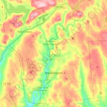
Name: Washington topographic map, elevation, terrain.
Average elevation: 823 ft
Minimum elevation: 358 ft
Maximum elevation: 1,270 ft
Northwest Hills Planning Region trails, hiking, mountain biking, running and outdoor activities
Other topographic maps
Click on a map to view its topography, its elevation and its terrain.
The Matterhorn
United States > Connecticut > Northwest Hills Planning Region > Canaan
Average elevation: 1,516 ft
East Hartland
United States > Connecticut > Northwest Hills Planning Region > Hartland
Average elevation: 1,102 ft
West Goshen
United States > Connecticut > Northwest Hills Planning Region > Goshen
Average elevation: 1,270 ft
Burrville
United States > Connecticut > Northwest Hills Planning Region > Torrington
Average elevation: 958 ft
South Kent
United States > Connecticut > Northwest Hills Planning Region > Kent
Average elevation: 620 ft
Thomaston Rod & Gun Club
United States > Connecticut > Northwest Hills Planning Region > Litchfield
Average elevation: 915 ft
Sharon Avenue Park
United States > Connecticut > Northwest Hills Planning Region > Torrington
Average elevation: 751 ft
Tyler Lake Heights
United States > Connecticut > Northwest Hills Planning Region > Goshen
Average elevation: 1,325 ft