
Sunrise Park topographic map
Interactive map
Click on the map to display elevation.
About this map
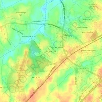
Name: Sunrise Park topographic map, elevation, terrain.
Average elevation: 735 ft
Minimum elevation: 656 ft
Maximum elevation: 801 ft
Other topographic maps
Click on a map to view its topography, its elevation and its terrain.
Eagle Heights
United States > North Carolina > Rowan County > Salisbury
Eagle Heights, Salisbury, Rowan County, North Carolina, 28144, United States
Average elevation: 702 ft
Park View Heights
United States > North Carolina > Rowan County > Salisbury
Park View Heights, Salisbury, Rowan County, North Carolina, 28144, United States
Average elevation: 705 ft
Salisbury
United States > North Carolina > Rowan County > Salisbury
Salisbury, Rowan County, North Carolina, 28144, United States
Average elevation: 738 ft