
Thank you for supporting this site ❤️
Make a donation
Make a donation
Gear up for your next adventure:
As an Amazon Associate, this site earns from qualifying purchases at no extra cost to you.
Biramitrapur topographic map
Click on the map to display elevation.
Thank you for supporting this site ❤️
Make a donation
Make a donation
Gear up for your next adventure:
As an Amazon Associate, this site earns from qualifying purchases at no extra cost to you.
About this map
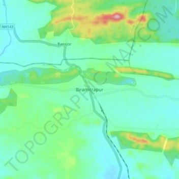
Name: Biramitrapur topographic map, elevation, terrain.
Location: Biramitrapur, Sundargarh District, Odisha, 770033, India (22.36654 84.69093 22.44654 84.77093)
Average elevation: 935 ft
Minimum elevation: 751 ft
Maximum elevation: 1,588 ft
Thank you for supporting this site ❤️
Make a donation
Make a donation
Gear up for your next adventure:
As an Amazon Associate, this site earns from qualifying purchases at no extra cost to you.