Geolocate

Plovdiv topographic map

Click on the map to display elevation.

About this map

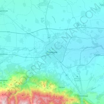
Name: Plovdiv topographic map, elevation, terrain.

Location: Plovdiv, 4000, Bulgaria (41.98185 24.58993 42.30185 24.90993)

Average elevation: 942 ft

Minimum elevation: 466 ft

Maximum elevation: 5,056 ft

Other topographic maps

Click on a map to view its topography, its elevation and its terrain.

Западен

Bulgaria > Plovdiv > Plovdiv

Average elevation: 564 ft

Hisaria

Bulgaria > Plovdiv

Average elevation: 1,719 ft

Южен

Bulgaria > Plovdiv

Average elevation: 568 ft

Източен

Bulgaria > Plovdiv

Average elevation: 522 ft

Южен

Bulgaria > Plovdiv

Average elevation: 568 ft

Централен

Bulgaria > Plovdiv

Average elevation: 551 ft

Gear up for your next adventure:

🏥Hiking First Aid Kits - Comprehensive medical kits for remote trail injuries
🪶Paracord Bracelet - Survival bracelet with built‑in tools
🖼️Topo Map Wall Art - Decorative topographic prints of famous peaks and regions
💧Water Purification System - Clean water on the trail with reliable purifiers
🪶Multi‑Purpose Knife - Useful blade for camp and trail

As an Amazon Associate, this site earns from qualifying purchases at no extra cost to you.