
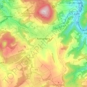
Rothselberg topographic map
Interactive map
Click on the map to display elevation.
About this map
Name: Rothselberg topographic map, elevation, terrain.
Average elevation: 1,171 ft
Minimum elevation: 627 ft
Maximum elevation: 1,768 ft
Rothselberg lies at the foot of the 546 m-high Selberg in the North Palatine Uplands. The village's elevation is some 340 m above sea level and it lies on the ridge between the Talbach and Lauter valleys. Near the village rises the Breitenbach, which flows into the Jettenbach about 3 km away to the northwest in Eßweiler. At the foot of the Selberg rises the Lammelbach, which flows through the Löffelmannsgraben and empties into the Lauter near the Schmeißbachermühle (a former mill). To the west, towards Jettenbach, the land rises up, peaking at the Eisenstein (460 m above sea level), while to the south, towards Kollweiler, it also rises, reaching the peak of the Galgenberg (“Gallows Mountain”) at 431 m above sea level. The municipal area measures 875 ha, of which 170 ha is wooded and 20 ha is built up.